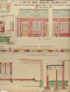
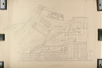
"A map says to you. Read me carefully, follow me closely, doubt me not… I am the earth in the palm of your hand."If this quote from aviator and adventurer Beryl Markham is to be true, then Cheshire Archives holds huge swathes of Cheshire’s earth, and beyond, in the hundreds of maps and plans in our railway collection. Plans of tracks, stations, bridges, tunnels, foot bridges, signalling, derailments, engine sheds, schools, goods yards, waiting rooms, lines that were built, lines that were never built - even the Station Master’s bathroom in Bebington.
Over the last few years lots of work has been carried out to list, organise and repackage these plans to make them available for the public to view. So join us in this exploration of Cheshire’s railways and hold the earth, or at least some of it, in the palm of your hand.
First stop - understanding the plans
For some of the plans it is clear why they were made and what they are trying to show. The plans of Runcorn Bridge, for instance, are easy to understand. They show the bridge from various angles and different sections and elevations, and it doesn’t require knowledge of railway engineering to appreciate them.Other plans are more complex. The estate plans of lines with lots of handwritten annotations are difficult to understand. Was the line built, or not? What is the date? Sometimes a date is clearly stamped, but it is obvious that these were working plans and the annotations were added over years or even decades. But take from them what you can. The estate plans are full of wonderful details outlining ownership of parcels of land adjacent to the lines. They can include details that may not be found between census records, Ordnance Survey maps or other well-used family and local history records.
The plans were made for many different reasons. Some reasons are clear - such as to plan the construction of a bridge or the planning of a railway line - but for other plans it is less clear what the purpose is for. In listing and organising the collection, we have tried to make it clear on our catalogue what information can be taken from them - even when the purpose of the plan is less clear. As with all archives, the information contained within them can far exceed the purpose for which it was captured.
Second stop - understanding the types of plans
Firstly, there are plans that were created by the Engineering Department. These include buildings such as stations, waiting rooms, engineering sheds and goods yards. They show what the building would have looked like externally and internally - often in great detail. They show measurements and exist in various scales. Sometimes they show the area around the building and its location in relation to the wider station plan.There are plans of bridges, tunnels, culverts and viaducts. These are very similar in detail to the plans of the buildings, but often include mile points that indicate their position on the railway line. Engineering plans also include inspection sketches and signalling with details of alterations to tracks, signalling, sidings and junctions. There are also many more varied plans of engineering works such as drainage, line widening, and track plans.
The second series of records are those created by the Estate Department. These are more complex and can be difficult to understand. They largely consist of plans showing the full line or a section of a line. In their most basic sense, they show the routes and the land around them. They are full of details such who owned the land adjacent to the line. This is great if you are researching a nearby property or piece of land, especially if no other mapping exists for that point in time.
The plans are drawn to various scales but the most common are the 2 chains to 1 inch surveys (1 chain=22 yards). They can be individual plans of a section of a line, or can be many plans bound together in large unwieldly volumes. They are often annotated with details that sometimes can be easy to understand or sometimes complex and technical. They are often stamped with details of different railway companies and have clearly been used over many years. They have been listed on our catalogue with the start and end point of the line, with details in the description of the stations in between which are featured.
The plans on our online catalogue are arranged under three sections; engineering plans, estate plans, and deposited parliamentary plans. The deposited parliamentary plans are a shorter series and compliment those deposited plans in our Quarter Session records (see QDP). Within each section they are sub-divided into types of plans such as ‘stations and buildings’, ‘line sections’ etc. Within each series they are listed alphabetically by place. A further guide is in progress that will allow researchers to identify which line a station or structure sat on and if we hold plans. Watch this space for further details on this.
The railways covered a lot of earth and the plans cover a large portion of this. Search our catalogue to discover the full extent and arrange a visit to the Record Office to hold them in the palm of your hand.
Third stop - understanding the scope
The lines didn’t stop at county boundaries and neither do the railway plans. As such, it follows that a lot of the plans go beyond the scope of Cheshire. There are many plans for neighbouring counties but also many from much further afield including lines in Ireland and Wales. The plans are listed in good detail on our catalogue, so a search for the place of interest should be easily found.
Final destination - the catalogue
The plans on our online catalogue are arranged under three sections; engineering plans, estate plans, and deposited parliamentary plans. The deposited parliamentary plans are a shorter series and compliment those deposited plans in our Quarter Session records (see QDP). Within each section they are sub-divided into types of plans such as ‘stations and buildings’, ‘line sections’ etc. Within each series they are listed alphabetically by place. A further guide is in progress that will allow researchers to identify which line a station or structure sat on and if we hold plans. Watch this space for further details on this.The railways covered a lot of earth and the plans cover a large portion of this. Search our catalogue to discover the full extent and arrange a visit to the Record Office to hold them in the palm of your hand.
All of these items are available to view at Cheshire Record Office in Chester. Part 1 of this blog is First Stop - The History and Part 2 is Second Stop - Employee Records.


No comments:
Post a Comment